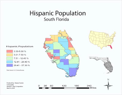
 This is the second map made in Adobe Illustrator. I could change the colors of the symbols, but never got the direct select tool to work witht the counties. I got the state of Florida to change to red but could not get just the south part of the state to change away from gray to red. Plan to change the colors to more of a gradient and move the symbol rectangles together to show the gradual change in the groups. Spaces typically indicate more distinct breaks. The was not a year for the census data so not sure if it was 1990 or 2000.
Monday, March 9, 2009
Module 4 Map Design Hispanic Population
 This is the second map made in Adobe Illustrator. I could change the colors of the symbols, but never got the direct select tool to work witht the counties. I got the state of Florida to change to red but could not get just the south part of the state to change away from gray to red. Plan to change the colors to more of a gradient and move the symbol rectangles together to show the gradual change in the groups. Spaces typically indicate more distinct breaks. The was not a year for the census data so not sure if it was 1990 or 2000.
Sunday, March 8, 2009
Marathon Map in Adobe Illustrator
Subscribe to:
Comments (Atom)

